|
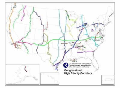
NHS High Priority Corridors
(Note: Consider as you view this national map, how The Wildlands
Project Map 'overlays' it, and how the huge north-south 'predator
corridors' -- vast roadless areas off limits to humans -- are
part of this 'high priority corridors' FHWA map.)
HEP - Planning, Environment and Realty, also known as the Federal
Highway Administration (FHWA) Office of Planning, Environment and
Realty http://www.fhwa.dot.gov/hep/index.htm and
http://www.fhwa.dot.gov/hep/aboutus.htm
BackgroundBeginning with the ISTEA, over 40 corridors have been designated in Federal transportation legislation as high priority corridors on the National Highway System (NHS) and are included in the 163,000-mile approved NHS as specific routes or general corridors. (Some of the corridors are part of longer high priority corridors.) Some of the corridors are entirely within a single State; some are multi-State corridors. (e.g., the Sarnia, Ontario, Canada to Lower Rio Grande Valley, Texas, corridor and the Sault Ste. Marie, Michigan, to Charleston, South Carolina, corridor). Some of these corridors are described in detail in legislation while others are broadly defined. Funding - ISTEASection 1105(f) of ISTEA authorized funding for fiscal years 1992 through 1997 for some specific high priority corridor segments, and Section 1105(h) authorized some additional funding for high priority corridor feasibility and design studies. NHS, STP and Bridge Program funds authorized by ISTEA may be used to fund improvements to high priority corridors. In certain instances, Interstate Maintenance funds authorized by ISTEA may be used to fund improvements to some high priority corridor routes. Funding - TEA-21Section 1602 of TEA-21 authorizes funding for fiscal years 1998 through 2003 for some specific high priority corridor segments. Also, formula funds for the NHS, STP, Bridge Program, and in certain instances, Interstate Maintenance authorized by TEA-21 may be used to fund improvements to high priority corridors. In addition, beginning in FY 1999, the planning and development of high priority corridors will be eligible for funding under the discretionary National Corridor Planning and Development Program. Designations as Interstate RoutesSection 1105(e) of the ISTEA, as amended, designates all or portions of nine high priority corridors as future parts of the Interstate system and authorizes the Secretary to add segments of the corridors to the Interstate System when certain criteria are met. Location of CorridorsStatutory listing of Corridor Descriptions: http://www.fhwa.dot.gov/hep10/nhs/hipricorridors/hpcor.html Corridor numbers correspond to Statutory listing in Section 1105(c) of ISTEA, as amended http://www.fhwa.dot.gov/hep10/nhs/hipricorridors/hpcorqk.html http://www.fhwa.dot.gov/hep10/nhs/hipricorridors/highpri2.jpg View a larger version (100 KB, 1056x816) http://www.fhwa.dot.gov/hep10/nhs/hipricorridors/hiprimap.html or PDF (1.3 MB) http://www.fhwa.dot.gov/hep10/nhs/hipricorridors/hipri-big.pdf for printing. (PDF format requires the free Acrobat plugin available at www.adobe.com.) Information valid as of September 23, 2002. ContactMartin Weiss, [email protected] or 202-366-5010
This page last modified on March 12, 2004
|

