http://209.10.107.181/website/tx_3/viewer.htm
http://www.aaroads.com/high-priority/
http://www.aspensite.com/gwa/map-roaded.html
http://www.biologicaldiversity.org/swcbd/species/mso/CHMap.html
http://www.biologicaldiversity.org/swcbd/species/mso/news.html
On August 27, 2001, the Center for Biological Diversity, Navajo
environmental organization Din� Citizens Against Ruining Our
Environment (Din� Care), and Colorado based Center for Native
Ecosystems sued the Fish and Wildlife Service over its recent critical
habitat designation for the Mexican spotted owl. While Fish and Wildlife
Service originally proposed designating over 13 million acres of
federally owned land in Arizona, New Mexico, Utah, and Colorado as
critical habitat, the final designation only identifies 4.6 acres. The
groups are suing because the final rule eliminated almost 9 million
acres of proposed habitat-largely within Arizona and New Mexico National
Forests, where 90% of known owls exist and not one acre was designated
as critical habitat.
Acreage Proposed:
AZ: 5,000,000 million
NM: 4,600,000 million
CO: 570,000
UT: 3,300,000
Acreage Final:
AZ: 830,803
NM: 53,746
CO: 524,731
UT: 3.2 million
Roadless and Wilderness in critical habitat:
AZ proposed: 1,034,191
AZ final: 54,903
http://www.blm.gov/nlcs/map.htm
Map of the National Landscape Conservation System
http://td.ci.columbus.oh.us/hellbranch/_private/hellbranch.pdf
http://www.columbusinfobase.org/_private/growth_map.htm
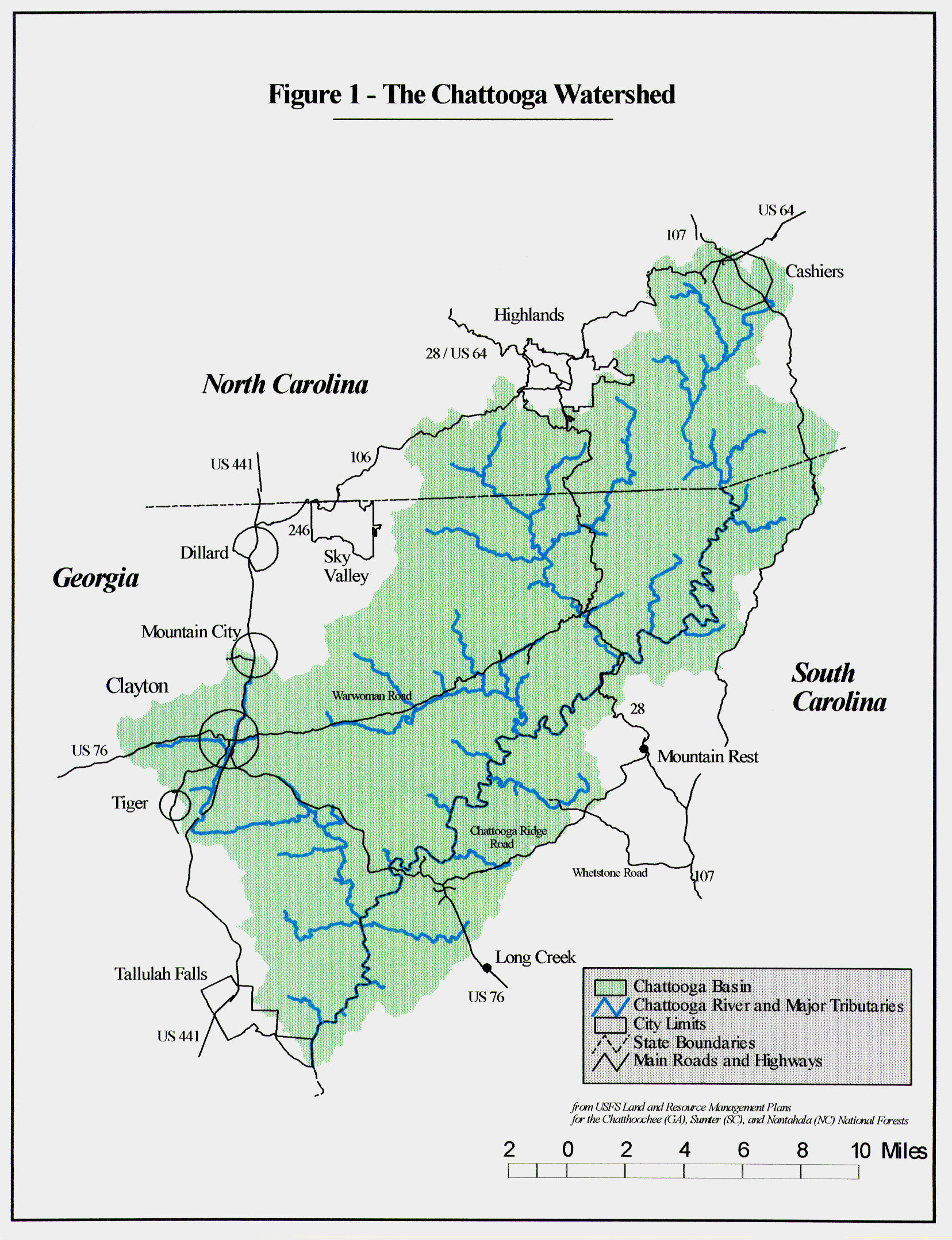
http://www.conservationgis.org/ctsp/chattoo/chat1.gif
http://www.conservationgis.org/ctsp/chattoo/chattoo.html
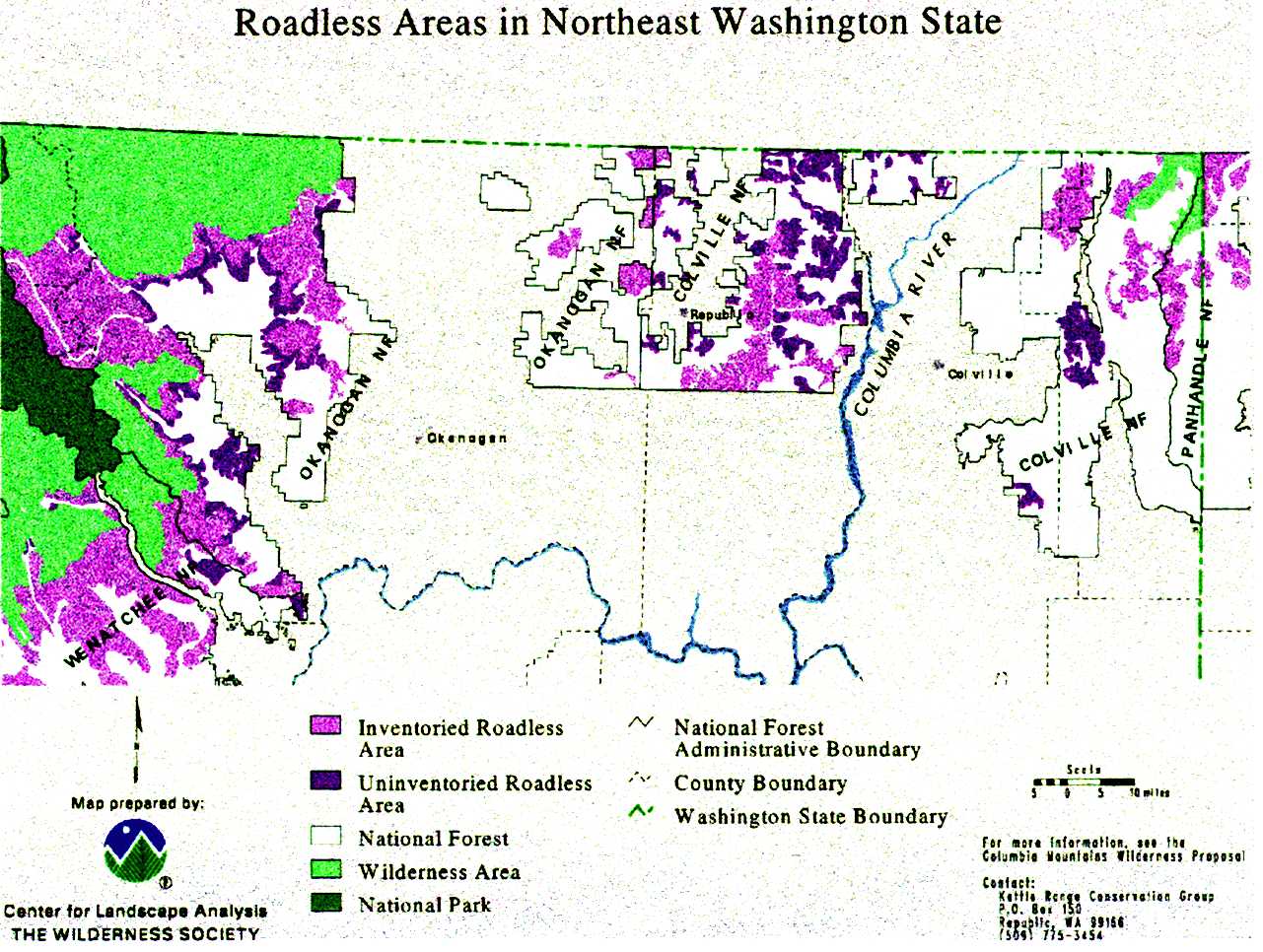
http://www.conservationgis.org/ctsp/tws/rdless95.jpg
http://www.conservationgis.org/ctsp/tws/twildsoc.html
http://www.dcnr.state.pa.us/rails/maps.html
http://www-dial.jpl.nasa.gov/~charles/earth.html
http://www.earthjustice.org/backgrounder/documents/stellar_habitat.pdf
http://www.enhancements.org
http://www.epa.gov/ceisweb1/ceishome/atlas/
EQEnvironmental Atlas
http://www.epa.gov/epahome/aboutepa.htm
http://www.epa.gov/epahome/whereyoulive.htm
http://www.epa.gov/eq/sitemap.html
http://www.epa.gov/iwi/
Introduction: Index of Watershed Indicators
http://cfpub.epa.gov/surf/state.cfm?statepostal=VA
http://cfpub.epa.gov/surf/state_list.cfm
(click on state for map)
http://www.epa.gov/wateratlas/geo/ii16_usmap.html
(National Map of Forest Riparian Habitat)
http://www.floods.org/mit%20succ%20stories/mitsucc.htm
http://www.forestwatchalberta.ca/az_index.html�
(Canada; at least 8 maps here)
http://www.fs.fed.us/r2/nebraska/gpng/pawn.html
http://www.fs.fed.us/r4/uinta/forest_plan/roadless/rlmap.html
http://www.gisdatadepot.com/
http://www.greenmap.org
http://www.headwaters.org/
http://www.headwaters.org/archive/endangered_fishing/salmon_map.html�
http://www.headwaters.org/archive/roadless_areas/index.html�
http://www.headwaters.org/archive/roadless_areas/kal_map.html
Headwaters | Kalmiopsis Wildlands Map
http://www.headwaters.org/archive/roadless_areas/off_road.html�
http://www.headwaters.org/archive/roadless_areas/unprotect_soda.html�
http://www.headwaters.org/archive/roadless_areas/unprotected.html�
http://www.headwaters.org/archive/timber_sales/big_trees.html�
http://www.headwaters.org/archive/timber_sales/dagger.html
http://www.headwaters.org/archive/wilderness/elk_river.html�
http://www.headwaters.org/archive/wildlands/index.html�
http://www.hupc.org/lakes_area_map.htm
http://www.intellweb.com/trails/trails.htm�
http://www.jarbidgeshovelbrigade.com/maps.htm
http://www.ku.edu/~hisite/franklin/railtrail/trailmap.htm
http://lcweb2.loc.gov/ammem/gmdhtml/gmdhome.html
http://www.lib.ncsu.edu/archives/greenways/midwest.html
http://www.lib.ncsu.edu/archives/greenways/newengland.html
http://www.lib.ncsu.edu/archives/greenways/northamerica.html
http://www.lib.ncsu.edu/archives/greenways/pacific.html
http://www.lib.ncsu.edu/archives/greenways/southern.html
http://www.lib.ncsu.edu/archives/greenways/us.html
http://www.lib.ncsu.edu/archives/greenways/western.html
http://www.lib.ncsu.edu/archives/greenways/world.html
http://www.lib.ncsu.edu/archives/greenways_pre20011018/maps.html
http://www.lib.ncsu.edu/stacks/gis/
http://www.lib.utexas.edu/Libs/PCL/Map_collection/Map_collection.html
http://www.lib.utexas.edu/maps/national_parks.html
UT Library Online - Perry-Casta�eda Map Collection - Maps of United
States National Parks and Monuments
http://www.lib.washington.edu/subject/USMaps/dr/elmap.html
http://www.mapquest.com/
http://maps.grida.no/kyoto/
http://mapstoremn.com/freetopo.htm
http://mpa.gov/mpaservices/atlas/fig3_endcrit_map.html
http://www.nebraskansfirst.com/latest_news.htm
http://ngmdb.usgs.gov/ USGS
NATIONAL GEOLOGIC MAP DATABASE - HOMEPAGE
http://ngmdb.usgs.gov/ngmdb/define.html
USGS NATIONAL GEOLOGIC MAP DATABASE -
Geologic Theme Definitions
http://ngmdb.usgs.gov/ngmdb/ngm_catalog.ora.html
USGS National Geologic Map Catalog
http://www.nhq.nrcs.usda.gov/land/index/intro.html
State of the Land -- Index to Maps, Facts, and Figures
http://www.nhq.nrcs.usda.gov/land/index/nri97maps.html
(there are 326 maps at this site!)
http://nris.state.mt.us/gis/mtmaps.html�
Maps of Montana
www.pdfs/1218huyc.pdf
http://plasma.nationalgeographic.com/mapmachine/plates.html
http://www.rachel.org/orgList/orgResults.cfm?map=World&country_ID=all
http://www.railtrails.org/RTC_active_pages/Home/Main.asp
http://www.rapidcityjournal.com/display/inn_news/news01.txt
Public comment sought on Wind Cave changes
HOT SPRINGS -- Starting today, you can help Wind Cave National Park
decide its proposed 6,555-acre expansion. Technically, the National Park
Service calls it a "boundary adjustment." Whether anything
happens depends on an environmental assessment, including the 30-day
public-comment period through May 7. The land includes 5,555 acres on
the Milliron and Casey ranches. The park also is interested in acquiring
80 acres of Bureau of Land Management (BLM) property, 880 acres of South
Dakota Public School Lands, and 40 acres of private land for sale by the
owner. (See map)
"The proposed boundary adjustment would improve wildlife habitat,
increase recreational opportunities, protect significant archeology
sites and support management of the park's existing land,"
according to the park service. Wind Cave National Park currently
protects 28,295 acres of mixed-grass prairie and forest in Custer County
adjoining Custer State Park, Norbeck Wildlife Preserve and Black Hills
National Forest lands. Park Superintendent Linda Stoll said an informal
open house will be held from 3 p.m. to 8 p.m. Thursday, April 18, at the
Wind Cave Visitor Center to discuss the plan. Copies of the
Environmental Assessment can be found on-line at www.nps.gov/wica.
In addition, printed copies are available for review at the Custer and
Hot Springs public libraries and at Wind Cave National Park visitors'
center. The public can comment on the plan by writing to Park
Superintendent; Wind Cave National Park; RR 1, Box 190; Hot Springs, SD
57747 or at [email protected].
Register/2001/Sep/06/46575A.pdf
http://roadless.fs.fed.us/documents/feis/specrep/xlandscape_spec_rpt.pdf\
http://roadless.fs.fed.us/maps/usmap.shtml
http://roadless.fs.fed.us/maps/usmap2.shtml
Roadless Area Conservation Maps
http://search.atomz.com/search/?sp-q=wilderness+maps&submit=Search&sp-a=000507
d3-sp00000000
www.setonresearchcenter.com/
http://www.sharetrails.org/roadless/roadless/map.html
http://www.sierraclub.org/sprawl/report98/map.html
http://www.teachingkate.org/dirt.htm
http://www.texasep.org/html/atlas.html
http://www.topozone.com/
http://www.uawcd.com/maps.htm
http://www.watershed.org/geolinks.html
http://web.mit.edu/urbanupgrading/urbanenvironment/site-map/
http://www.wetlandstudies.com/
http://www.unep.net/profile/index.cfm
http://www.unep.net/profile/index.cfm?tab=100&countrycode=US&submit=Go
http://water.usgs.gov/watuse/wumaps.color.html
USGS National Water-Use Data - Water Use Maps
www.wilderness.org
Searched for "Map" on The Wilderness Society website: Your
search returned 309 matches.�
http://www.wilderness.org/backyard/flyways/atlanticroutemap.htm
http://www.wilderness.org/backyard/flyways/atlanticroutemap.htm
http://www.wilderness.org/backyard/flyways/mississippiroutemap.htm
http://www.wilderness.org/backyard/flyways/pacificroutemap.htm
http://www.wilderness.org/ccc/cla/
http://www.wilderness.org/ccc/southeast/hikeat/map.htm
http://www.wilderness.org/newsroom/15most/2001/list.htm�
(13 states, 8 maps -- for example, there is a map of the San Joaquin
Roadless Area in CA; also one of the 'Greater Yellowstone and Grand
Teton National Parks' showing the larger 'ecosystem' involving much
larger areas of three states -- Montana, Wyoming, and Idaho -- than the
parks encompass)(in Montana, there is an amazing map clearly showing the
mosaicing of the different land parcels, their edges matching
PERFECTLY!)
http://www.wilderness.org/newsroom/roadless_091900_maps.htm
http://www.wilderness.org/own/states2/west.htm
http://www.wilderness.org/wild/network/mapping_wildness.pdf��������������
Map 1Article in HTML (very important site)
http://www.wildlandsprojectrevealed.org/htm/show/page2.htm
�
http://www.wildlandsprojectrevealed.org/htm/show/page4.htm
(national maps showing the 'vision' for black bear, wolf and grizzly
bear range; 'wonder why the playground of Jackson Hole, Wyoming is
spared from grizzlies?)
�
http://www.wildlandsprojectrevealed.org/htm/show/page5.htm
http://www.wildlandsprojectrevealed.org/htm/show/page7.htm
�
http://www.wildlandsprojectrevealed.org/htm/sitemap.htm
http://www.wildlandsprojectrevealed.org/htm/roads.htm
(Roads:� Since roads provide human access to remote areas, perhaps
it should come as no surprise that an organization has formed which has
as its primary objective the closing and removal of roads on public
lands.
The Road Removal Implementation Project (ROAD-RIP) grew out of The
Wildlands Project's (TWP) vision with the primary purpose of laying,
"�the groundwork for protecting and restoring wildland ecosystems
by eliminating roads." This is necessary because in order to expand
the system of reserves and corridors envisioned by TWP, large roadless
are needed throughout the continent. Viewing connectivity as a key,
ROAD-RIPpers ask, "�what bigger disrupter of connectivity is
there than a road?" Therefore, according to an article in Wild
Earth (Winter 1995/96) by Kraig Klungness and Katie Alvord Scarborough
(co-founders of ROAD-RIP), ROAD-RIP, "�has the same ultimate goal
as TWP: big wilderness as home for the unimpeded evolutionary journeys
of North America's myriad native species."
In January 1997, ROAD-RIP changed its name to the less abrasive
Wildlands Center for Preventing Roads, Wildlands CPR. According to
information released by the organization, "Our focus is specific:
Wildlands CPR seeks the protection and recovery of large-scale
wilderness and biodiversity by removing roads and preventing new road
construction on public lands." The Wildlands Project and the
Biodiversity Legal Foundation, "a non-profit organization which
pursues aggressive legal strategies to preserve native wild plants and
animals, communities of species ecosystems, and natural
landscapes", lead the Wildlands CPR coalition.
Claiming that, "THE ROAD TO WILDERNESS RECOVERY�IS NO ROAD AT
ALL," Wildlands CPR maintains that the best road density goal for
maintaining and restring ecological processes is, "ZERO-NO ROADS AT
ALL." Their definition of a road "includes everything from
interstate highways down to two-track logging roads, off-road vehicle
trails, and snowmobile routes." By using TWP vision maps, Wildlands
CPR is targeting the roads necessary for closing in order to bring about
large-scale North American wilderness recovery.
Believing that, "In order to assure the connectivity that TWP
envisions, we need to close roads-lots of roads-�" Wildlands CPR
maintains that a program like theirs is essential to the success of The
Wildlands Project. Klungness and Scarborough write that Wildlands CPR,
"will help make the grand vision of The Wildlands Project a
reality, piece by roadless, interconnected piece."
To help activists close and remove roads ROAD-RIP published a series of
guides in 1995 and 1996 collectively distributed as the ROAD-RIPPER'S
HANDBOOK. The publication of these guides was made possible by the
financial support of the Conservation Alliance and the Foundation for
Deep Ecology. While one would naturally assume that there would be
guides for Forest Service (FS), and Bureau of Land Management (BLM)
lands since these have traditionally supported resource industries,
there is also a guide for National Park Service (NPS) land. Since NPS
lands are primarily intended for recreational and educational use, some
might find it surprising that Wildlands CPR would object to access of
these lands too.
In the 1999 January/February issue of The Road-RIPorter Bethanie Walder,
Director of Wildlands CPR wrote, "As simple as it may seem, if we
can stop the roads now, then we have a lot less timber sales, mines and
motorized recreation to stop later." On the basis of that statement
it is apparent that Ms. Walder considers motorized recreation (the most
popular form of public land recreation) to be undesirable too. Indeed,
one of the guides distributed in the HANDBOOK is titled, "The
Road-Rippers Guide to Off-Road Vehicles." In a Road-RIPorter
article published in 1997, Marianne Moulton criticized non-motorized
recreation as well, writing, "As more Americans find their way into
the backcountry, the unknown risks to the natural world increases. The
shocking truth is that trails have impacts similar to roads. (emphasis
added)" Recreation on public lands also came under censure in an
article by Scott Silver concerned about the Forest Service's increasing
emphasis on what Silver referred to as "industrial
recreation." Silver wrote, "With recreation fueling the agency
bureaucracy, forest activists may need to shift at least some of their
attention from timber to recreation�If managed poorly, or managed
primarily as a cash generating tool, then a shift to "Industrial
Recreation" is hardly an improvement over the old Forest Service
ways." Silver seems most disturbed about the Forest Service's
recreation fee program, calling it "just another tax", and the
partnership between the Forest Service and the American Recreation
Coalition (ARC). This view of the fee program draws an interesting
comparison. For years, Forest Service recreation has been the most
heavily subsidized program of the Service. In 1997 (the last year for
which figures are available), the Forest Service recreation program lost
$264.6 million. After years of arguing for the elimination of money
loosing timber sale programs, one can now wonder if activists will show
similar fiscal concern when it comes to recreation. In any event,
Wildlands CPR seem determined to resist almost any type of public land
use that requires access. Something recreational enthusiasts might want
to consider when determining if they should support The Wildlands
Project.
-------------------------------
http://www.wildlandsprojectrevealed.org/htm/states/al.htm
http://www.wildlandsprojectrevealed.org/htm/states/ga.htm
http://www.wildlandsprojectrevealed.org/htm/states/ky.htm
http://www.wildlandsprojectrevealed.org/htm/states/nc.htm
http://www.wildlandsprojectrevealed.org/htm/states/sc.htm
http://www.wildlandsprojectrevealed.org/htm/states/tn.htm
�
http://www.wildlandsprojectrevealed.org/htm/states/wv.htm
|